Acoustic Reference Area Kwinte
Why an acoustic Reference Area?
Hydrographic measurements are nowadays mostly carried out using multibeam echosounders (MBES) which scan the seabed with multiple sound waves. These acoustic signals reflect on the seabed and the echoes are captured by the echosounder, making it possible to chart the sea floor with a high level of detail. The measurements need correction for ship movement and use high resolution GNSS (Global Navigation Satellite System), assigning to each measured point x and y coordinate. By measuring the time between transmitting and receiving the acoustic signal, the vertical distance (z coordinate) can be deduced. These result in depth of the seabed and are called bathymetric measurements. Simultaneous with the bathymetry, multibeam systems are capable of measuring the strength of the returning acoustic signals. The nature of the sediment on the seafloor has a major impact on these measurements. They are called backscatter measurements, and can be translated into maps giving an idea of the nature of the sediments.
As the hydrographic vessel is sailing a distinct line pattern, full coverage measurements of the seabed are made.
As each hydrographic vessel has its own setup of sometimes different equipment, there is a need to calibrate these systems on a well-known area and to validate the quality of their measurements. This can be done on a small area which has a stable and homogeneous seabed, meaning that the seabed only minorly changes over the years. Extensive survey work by Flemish Hydrography (VH) and Continental Shelf Service (COPCO) over a small calibration area, called the Kwinte reference area, has been carried out during the last decade. Multiple surveys allow to cross-checking the depths and positioning of these different measurements and to build up a reference model of this area. Based on this extensive time series, it is clear that this area would fit the purpose ideally.
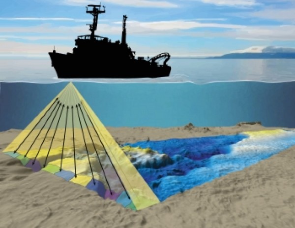 Principle of multibeam echosounder for bathymetry (Source: Applied Oceans Research Group, Nova Scotia Community College)
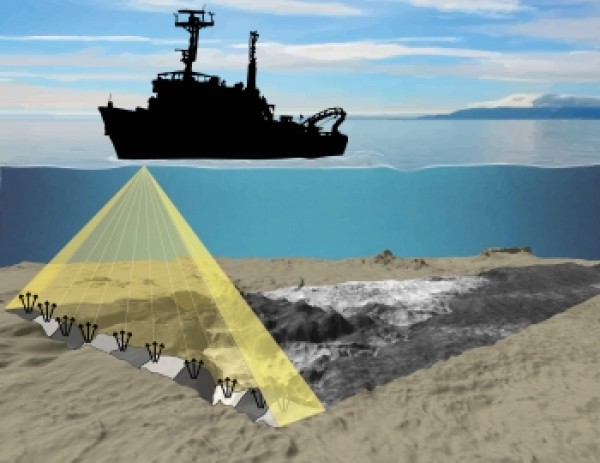 Backscatter strength data aqcuisition. (Source: Applied Oceans Research Group, Nova Scotia Community College)
Why is the Kwinte area a good reference area?
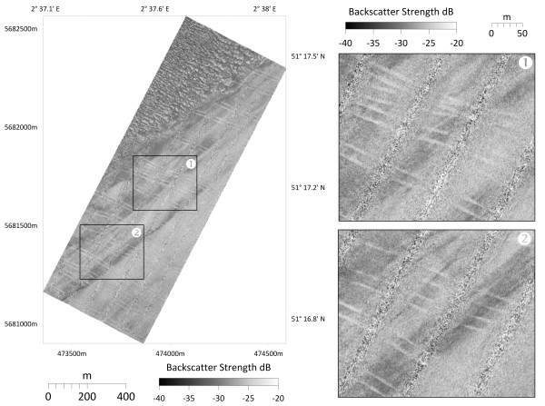 This image show trawling marks in the Kwinte reference area revealed by backscatter mosaic. Each light gray lineament represents one trawl trace.
Since 2009, extensive MBES surveys of the Kwinte area were carried out by the Continental Shelf Service of the Federal Public Service Economy (COPCO) and the Flemish Hydrography (VH) using multiple MBES installed on several vessels, with different setups and at different times. The resulting long time series of bathymetric and backscatter data demonstrates that the seabed remains remarkably stable throughout the years. Over a period of 10 years, the Kwinte reference area can be considered stable regarding bathymetry, showing neither significant accretion or erosion of the seabed. This demonstrated stability gives the Kwinte area the status of an ideal reference area for bathymetry and backscatter measurements.
The Kwinte reference area has been defined in the Marine Spatial Plan (MSP) 2020 - 2026 for the Belgian Part of the North Sea as a reference area for underwater acoustic sensors. In practice, all seabed disturbing activities are prohibited inside this reference area in order to preserve at long-term an undisturbed seabed for bathymetric and backscatter measurements.
Seabed anthropic alteration cannot be overlooked, as trawling marks are clearly visible on some backscatter images of the Kwinte area. Any impact by human activities (trawls, anchors, dredging,...) on the seabed surface will change the bathymetry and by modifying the sediments, induce a change of the backscatter level.
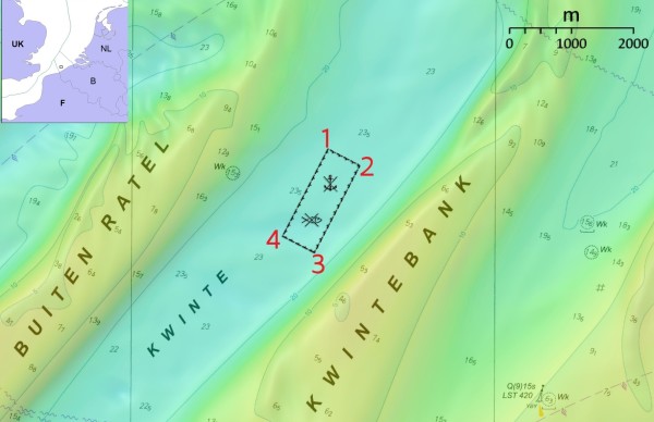 The image below shows the Kwinte reference area as defined in the Marine Spatial Plan. You find the coordinates of the indicated angular points in the table.
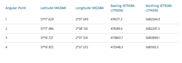 The MSP (Article 19 §3) describes it as follows: "A reference area is defined for calibration, quality evaluation and mutual comparison of acoustic elements in the gulley between Kwintebank and Buiten Ratel as only this area fulfills the requirements for a flat and anisotropic seabed." The MSP (Article 19 §3) provides the legal coordinates of this area.
WHAT DOES THE KWINTE REFERENCE AREA LOOK LIKE?
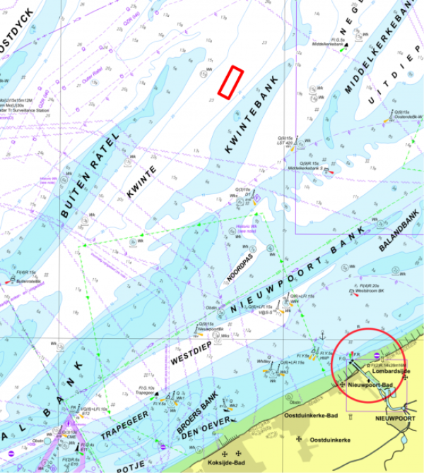
The Kwinte reference area lies about 17 kilometres before the coast of Nieuwpoort, in the Kwinte trough between the Kwintebank and Buiten Ratel, both sandbanks.
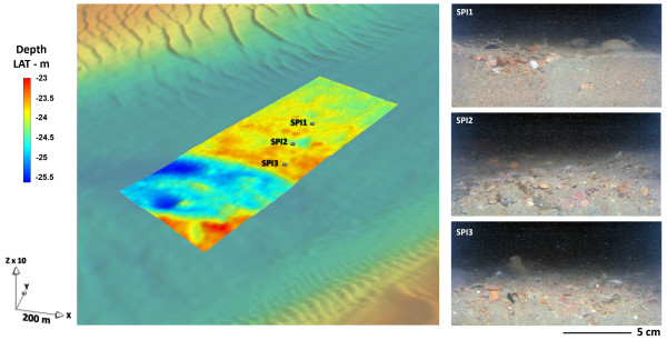
The reference area has a length of 1 km and a width of 440 m and is oriented at N60°. The water depths are ranging from 23 to 26 m LAT (Lowest Astronomical Tide).
The larger KWINTE area is to a large extent flat. Slope breaks affect its southern part. They are related to a differential erosion of clay of Ypresian age (Paleogene, Kortrijk Formation) directly underlying the gravel cover in this place. The NW part is shaped by a network of small to medium dunes of 10–30 m wave length and 0.2–0.3 m amplitude with crests oriented at N320°. No dunes are observed in the SE part of the larger KWINTE area which is dominated by rounded and irregular hills and depressions of decimetric height forming a typical hillocky morphology characteristic of the relatively flat gravel areas of the troughs in the Belgian part of the North Sea.
In the Kwinte channel, tidal currents can reach up to 1 m/s during periods of spring tides and remain around 0.5 m/s during neap tides. The current tidal ellipses are strongly elongated along the main axis of the channel.
Overall, the sedimentary cover of the KWINTE reference area consists of gravelly Sand (gS) and sandy Gravel (sG) (Folk 1954) with a high carbonate content exceeding 15%, due to the abundance of shells. These gravels that line the channels of the Flemish sandbanks correspond to lag deposits linked to a differential erosion by tidal currents of the gravel deposits.
USE THE MODEL AND CONTRIBUTE TO ITS IMPROVEMENT
The Kwinte reference area and model are open to use for every public or private institute or company that carries out multibeam MBES measurements. Ask for the bathymetric reference model at our project partners. All interested parties can use the model, using their own tools, to calibrate their MBES setup with this well-established reference. To improve our model, we ask to provide us your entire data set. After an accurate evaluation, we will ask for approval to incorporate the results in the mean reference model calculation. The information regarding the approved survey can also be published on this website.
Only if the bathymetry meets the quality and specifications described, the backscatter data can be considered if available.
However, an accepted survey over the Kwinte area does not guarantee that all subsequent surveys with the vessel in other areas are also accepted. This is not the responsibility of the project partners.
How you can use the Kwinte reference area, what the survey requirements are and how the data will be evaluated is described further on this website.
How can you use the Kwinte reference area yourself?Project partners
The project of the Kwinte reference area has been a collaboration between different partners.
COORDINATING PARTNERS:
The team Flemish Hydrography of the agency for Maritime and Coastal Services
Collaborators: Samuel deleu, Johan Verstraeten, Kris VanparysContinental Shelf Service, FPS Economy, SMEs, Self-employed and Energy
Collaborators: Marc Roche, Koen Degrendele
SUPPORTING PARTNERS:
Royal Belgian Institute of Natural Sciences (RBINS) – Directorate Natural Environment
Collaborators: Giacomo Montereale Gavazzi, Vera Van LanckerFlanders Marine Institute (VLIZ)
Collaboratior: Thomas Vandorpe
Acknowledgments: The crews of all the contributing hydrographic and research vessels are acknowledged for the valuable and greatly appreciated cooperation and excellent navigation.